


There is a persistent belief—particularly among Western observers—that Ukraine’s borders, as they stood on the eve of 2014, were somehow sacrosanct, immutable, a fixed reality of the international order. This view betrays a profound ignorance of history. The notion that any European border, let alone Ukraine’s, is beyond dispute ignores the repeated redrawings of maps, the frequent rise and fall of territorial claims and the consistent reality of border changes through war, treaty and political maneuvering. Ukraine, in particular, is one of the most illustrative examples of this broader historical phenomenon. If there is a European country whose borders could be considered permanently settled, Ukraine is not it.
The history of Ukraine’s borders is a history of shifting sovereignties. The land that today constitutes Ukraine has been contested ground for centuries, passing through the hands of empires, republics and military occupations. Its territorial definition has been redrawn at least a dozen times in the last few hundred years, often at the whims of external forces. Its current borders, inherited from the collapse of the Soviet Union in 1991, are more of a historical accident than a product of some long-standing, organic national unity.
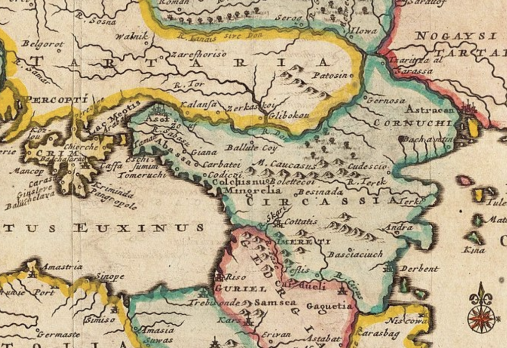
Consider the earliest configurations of the region. The medieval state of Kievan Rus, often cited as Ukraine’s foundational polity, was not a distinct Ukrainian entity but a loose federation of East Slavic principalities stretching from modern-day Belarus to Russia. It had no fixed borders in the contemporary sense, its influence waxing and waning with the strength of its rulers. When the Mongols sacked Kyiv in 1240, the remnants of Kievan Rus splintered, and control over Ukrainian lands shifted westward to the Grand Duchy of Lithuania. By the late 14th century, most of Ukraine was under Lithuanian or Polish control, its borders dictated by dynastic marriages and military conquests rather than any intrinsic national identity.
The Union of Lublin in 1569 transferred most of what is now Ukraine from Lithuanian to direct Polish control, integrating it into the Polish-Lithuanian Commonwealth. This arrangement lasted barely more than a century before the 1648 Cossack uprising against Polish rule created an autonomous Hetmanate in central Ukraine, a quasi-state that in turn sought the protection of Russia through the Pereyaslav Agreement of 1654. That agreement led, within a few decades, to Ukraine being partitioned along the Dnieper River between Poland and Russia—just one of many instances where Ukraine’s territorial fate was decided by external actors.
By the late 18th century, the collapse of the Polish-Lithuanian Commonwealth resulted in yet another reconfiguration. The Russian Empire absorbed Right-Bank Ukraine, while the Austrian Habsburgs took control of Galicia, Bukovina and Transcarpathia. At the same time, Catherine the Great expanded Russian control over southern Ukraine, annexing the Crimean Khanate in 1783. These changes laid the foundation for the Ukraine of the 19th century: a divided land, split between Russian and Austrian dominions, with no unified political existence of its own.
World War I and the Russian Revolution created another moment of flux. As the empires of Eastern Europe collapsed, multiple Ukrainian states were declared between 1917 and 1920—the Ukrainian People’s Republic, the West Ukrainian People’s Republic, even a short-lived Ukrainian Soviet Republic. But these fledgling entities were short-lived, crushed by Bolsheviks from the east and Poles from the west. The Treaty of Riga in 1921 formally divided Ukraine once again: western territories fell under Polish rule, while the east became the Ukrainian Soviet Socialist Republic, a constituent part of the USSR.
Even within the Soviet Union, Ukraine’s borders were not fixed. In the interwar period, the Ukrainian SSR lost some territory to the newly formed Moldavian Autonomous Soviet Socialist Republic in 1924. In 1939, following the Molotov-Ribbentrop Pact, Soviet troops invaded eastern Poland and annexed western Ukraine, shifting the republic’s borders westward. In 1940, Northern Bukovina and parts of Bessarabia were taken from Romania and added to Ukraine. In 1945, Transcarpathia was transferred from Czechoslovakia to Soviet Ukraine. These expansions completed the territorial shape of what would become independent Ukraine in 1991—but they were hardly natural or inevitable.
The last major border adjustment before Ukraine’s independence was the 1954 transfer of Crimea from the Russian Soviet Republic to the Ukrainian SSR. At the time, this move was largely symbolic, an administrative shift within the Soviet Union with little consequence. But when the Soviet Union collapsed, Ukraine’s leaders insisted that the inherited Soviet boundaries should be the inviolable borders of the new state. That position—embraced by Western policymakers in the post-Cold War settlement—ignored the long history of border fluidity in the region and the tenuousness of Ukrainian sovereignty over territories that had never been definitively “Ukrainian” in any historical sense.
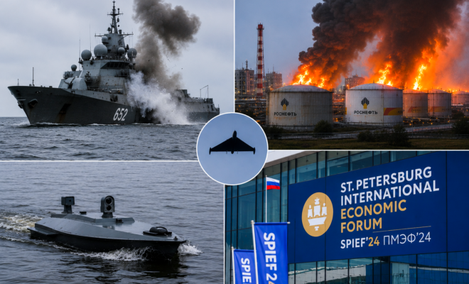
The events of 2014 and beyond fit into this broader historical pattern. Russia’s annexation of Crimea was not a sudden aberration but rather a return to a historical norm in which Ukraine’s frontiers were subject to external pressures and internal upheavals. The war in the Donbas, the contested status of Luhansk and Donetsk, and the shifting military lines in the current conflict all reinforce the reality that Ukraine’s borders—like those of much of Eastern Europe—are far from settled.
This does not mean that Ukraine’s sovereignty is illegitimate or that territorial integrity should not be defended. But it does mean that appeals to the supposed permanence of borders, as though they were some unchanging fact of nature, are fundamentally ahistorical. Ukraine, like Poland, Germany and countless other European nations, has had its borders drawn and redrawn by the forces of history. To claim that they are now unchallengeable is to ignore centuries of evidence to the contrary.
Sponsored by the John Milton Freedom Foundation, a nonprofit dedicated to helping independent journalists overcome formidable challenges in today’s media landscape and bring crucial stories to you.
READ NEXT: Renewed Assault: Trump’s TV Star Enforcer Doubles Down On Anti-Woke Agenda


Country borders have changed over time. Migrations, wars, conquering have changed borders to what they are now. Still some borders are or will change to this day. This article only focuses on Ukraine’s borders, but other European countries borders should be included as their borders were changed around the same time.
Would you volunteer America’s borders as well? Mexico has an historical claim to California, Utah, Nevada, New Mexico, and Texas; Russia has an historical claim to Alaska; France has an historical claim to the lands of the Louisiana Purchase; and the UK has an historical claim to the original 13 states. It is very easy to offer Russia 20% of Ukraine when one lives in America, but it would be much more uncomfortable to offer these parts of the US to their previous rulers.
Russia is a police state; one can be arrested and incarcerated at the will of the government and one’s property can be appropriated just as easily. The entire news media is government controlled; there is no freedom of speech or press in Russia. Ukraine may not be perfect, but there is more freedom there than in Russia. Ukrainians do not want to live under the Russian police state, or have their national identity erased by them. The Ukrainian and Russian languages are similar, but they are two distinct languages. Putin has made it clear that his goal is to take all of Ukraine and make it part of Russia; he does not want to alter their borders, he wants to erase them and the nation of Ukraine, permanently.
The title of your article mentions “A Century of Flux” but then the article ranges from the year 1240 through 1991. That’s over seven centuries. Also, the map doesn’t even include the Dnepr river, though it does show Ukraine as Tartaria extending out to the Don River.
And while it is true that part of the border changes of Ukraine extended west to incorporate L’vov (Lviv) which was a part of Poland prior to the Russian invasion of eastern Poland in 1939 (Lviv) and this city was also part of Austria-Hungary at one point (when it was called Lemburg), it means that the Poles really do have “skin” in this game if Ukraine is again taken over by Russia.
Similarly, Poland was carved up to the north when a large portion of its eastern territory was made a part of Belorus by the Russians.
So there is a LOT of animosity to the Russians in that part of the world, and to ignore that and view the USSR as the be-all and end game of this situation is not right.
The Russians thus have this ongoing tendency
And while we’re on this topic, what makes Russias borders permanent?
The issue with Ukraine’s borders is that Ukraine has been invaded by Russia; it did not negotiate border modifications with them. Historically borders have changed, but that has usually due to unilateral invasions and other types of wars; these changes have not been voluntary on the part of the nations whose borders were being changed. President Putin has stated in his writings that he wants all of Ukraine to become part of Russia; he does not want to alter Ukraine’s borders, he wants to end erase them and the existence of Ukraine as a nation.
It is easy for Americans living in safety to surrender 20% of Ukraine to Russia, but what if one day Mexico, with the support of one of America’s adversaries, perhaps China, decided to retake California, Utah, Arizona, Nevada, Texas, and New Mexico because they were once part of Mexico. What if Russia demanded that the US return Alaska? After all, it once did belong to Russia. Would Americans surrender those states for the sake of avoiding war, or would they fight for them? Clearly it is very easy watch another nation’s borders being “altered,” but an entirely different matter to have one’s own nation’s borders erased by an unprovoked military invasion.